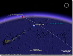
 According to first media reports, the U.S. interceptor hit the USA 193 satellite. An SM-3 interceptor was launched at 10:26 EST (21 February 2008 03:26 UTC) from a USS Lake Erie Aegis-class cruiser deployed in the Pacific Ocean near Hawaii (at about 24°35.42N 163°06.38W). The intercept was reported to take place three minutes later.
The picture on the left shows the position of the satellite at these times (click for a larger view).
The orbit is based on the elements posted by independent observers. According to these data, the intercept took place at the altitude of about 250 km. (DoD says the altitude was 247 km.) Here is the Google Earth kmz file  with the last revolution of the USA 193 satellite.
It is not clear if the intercept was successful in its declared goal - destroying the hydrazine fuel tank. The satellite apparently broke up - some debris were observed in Canada, but is not clear what happened to the tank. In fact, it is likely that that the tank would  not have survived the reentry anyway, so the intercept was not really necessary.
The picture of the right shows the ground track of the USA 193 in the 24 hours following the intercept. If anything comes down, it will come down somewhere along this path.
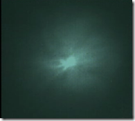
UPDATE 02/21/08: DoD posted a video of the intercept that shows interceptor launch and the result of the intercept (on the left). The explosion appears to be large enough to destroy the fuel tank, but I would reiterate that we don't know if it did.